


介绍 Map Pad GPS Land Surveys & Measurements
Use MapPad to calculate areas, perimeters and distances and save, export or share your measurements.
MapPad is providing multi-purpose mapping solution allowing location capture and determines distance and area for the shapes drawn on the map or captured using real-time GPS tracking.
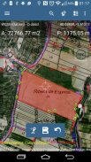
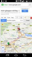
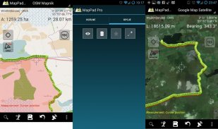
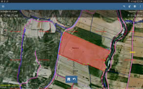
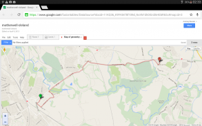
Calculate area of the field or a walk distance instantly using Google or Bing Map Satellite view. Save petrol and time and capture features with few clicks on the map.
With MapPad you can capture, manage and share your data easily.
MapPad is a very useful tool for anyone involved in forestry, agriculture, engineering and real estate management.
Please visit our website to find out how to prepare offline map and get more information about this product.
Selected features:
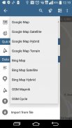
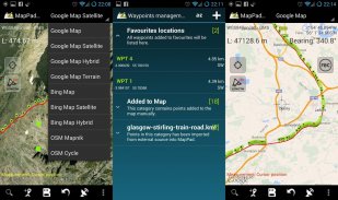
- Base maps: Google Maps, Open Street Map, Bing Maps
- Google Maps Overlays (Custom WMS or ArcGIS Server Tiled service), some layers like US Topographic map have been predefined.
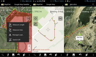
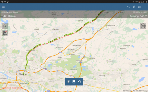
- Very accurate measurement of areas and distances.
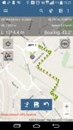
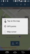
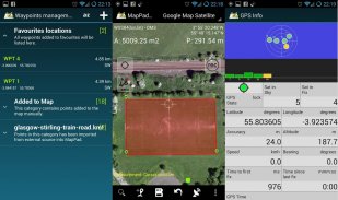
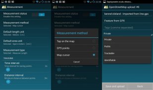
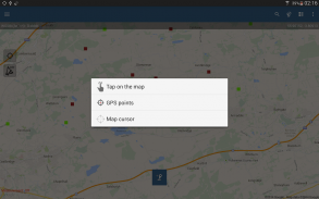
- 3 methods of measurement are supported (Tap on the map, GPS location, Map cursor location).
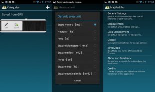
- Support for number of metric and imperial units.
- Support for several global and local coordinate systems, if you require support for any other spatial reference please get in touch.
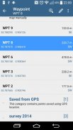
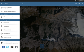
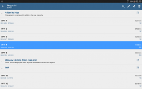
- Possibility to capture waypoints and group them in categories.
- Possibility to add or edit title and description for each recorded measurement and waypoint.
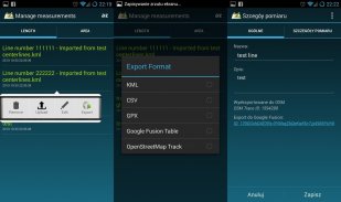
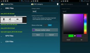
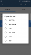
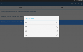
- Export single or multiple measurements or waypoints to SHP File, Geojson, ArcGIS Json, KML, GPX, CSV and DXF to SD Card or cloud services las well as direct export to Open Street Map.
- Share single waypoint location directly by SMS, E-mail or other ways.
- Elevation profile available for measurements done by GPS.
- Import of KML and GPX files to the application.
- GPS status and satellites status.
- Address, location search.
- Quick open exported KML files in Google Earth
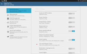
- Ability to set default measurement units, waypoints' categories colours, track recording time and distance interval, transparency of Google Maps overlays and much more...
Our users are successfully using MapPad in number of projects and applications.
使用MapPad计算面积,周长和距离,并保存,导出或共享测量值。
MapPad提供了多功能地图解决方案,可以进行位置捕获,并确定在地图上绘制或使用实时GPS跟踪捕获的形状的距离和面积。
使用Google或Bing Map Satellite视图立即计算出领域或步行距离。只需单击几下即可节省汽油和时间,并捕获功能。
使用MapPad,您可以轻松捕获,管理和共享数据。
对于从事林业,农业,工程和房地产管理的任何人,MapPad都是非常有用的工具。
请访问我们的网站以了解如何准备离线地图并获取有关此产品的更多信息。
所选功能:
-基本地图:Google地图,开放式街道地图,必应地图
-Google地图叠加层(自定义WMS或ArcGIS Server平铺服务),一些图层(例如美国地形图)已经预定义。
-非常精确的面积和距离测量。
-支持3种测量方法(在地图上点击,GPS位置,地图光标位置)。
-支持公制和英制单位的数量。
-支持多个全局和局部坐标系,如果需要支持任何其他空间参考,请联系。
-可以捕获航点并将它们分类。
-可以为每个记录的测量值和航路点添加或编辑标题和描述。
-将单个或多个测量值或航路点导出到SHP文件,Geojson,ArcGIS Json,KML,GPX,CSV和DXF到SD卡或云服务las,以及直接导出到Open Street Map。
-通过SMS,电子邮件或其他方式直接共享单个航点位置。
-高度剖面可用于GPS完成的测量。
-将KML和GPX文件导入到应用程序。
-GPS状态和卫星状态。
-地址,位置搜索。
-在Google地球中快速打开导出的KML文件
-能够设置默认的度量单位,航路点的类别颜色,跟踪记录时间和距离间隔,Google Maps叠加层的透明度等等。
我们的用户已在许多项目和应用程序中成功使用MapPad。
Map Pad GPS Land Surveys & Measurements - 版本7.5.0
(19-05-2019)
Map Pad GPS Land Surveys & Measurements - APK信息
APK版本: 7.5.0程序包: com.osedok.mappad同类应用
您可能还会喜欢……


